Geoscience Presentation BLOCK L14/50 Phetchabun Basin, Thailand February 18, 2014
Block 14/50 Geoscience Data Agenda Introduction Exploration History and Success Rates Production Review Previous Geophysical Data 2D Seismic data Seismic Analogues Seismic Leads 2012 Seismic Program Results APPENDIX A
Block 14/50 Geoscience Data Introduction
Block 14/50 Geoscience Data Phetchabun Basin Exploration and Production Blocks located in the Phetchabun Basin (outlined in blue). Block L14/50 is owned 100% by Oil Optimization Inc. No wells have been drilled in block…
Block 14/50 Geoscience Data Stratigraphic column in the Phetchabun Basin. Correlative stratigraphic units; source rocks; and reservoir rocks are all assumed to be present in the northern portion of the North/South trending…
Block 14/50 Geoscience Data Location of Schematic Geological CrossSections XX and YY. Line XX connects the Si Thep and Wichian Buri Fields. Both of these fields have producing Miocene clastic reservoirs, and the Wichian…
Block 14/50 Geoscience Data Schematic Stratigraphic CrossSections, Wichian Buri portion of the Phetchabun Basin.
Block 14/50 Geoscience Data Exploration History & Success Rates
Phetchabun Basin (Wichian Buri Area) Wells Drilled By Year 40 Success Rate Shown Above Column 35 76% 30 76% 79% 84% 25 Gas Oil D & A Wells Drilled Per Year 20 87% 15 10 75% 100% 60% 5 67% 0% 50% 50%…
Block 14/50 Geoscience Data Location of Producing Oil Fields, Wichian Buri Area, Phetchabun Basin. ECO Resources (Hong Kong) is Operator with 60% WI, Carnarvon Petroleum is 40%. Wichian Buri Area 2013 Q3 Gross Production…
Block 14/50 Geoscience Data Previous Geophysical Data
Block 14/50 Geoscience Data Map showing location of seismic lines used for seismic interpretation and mapping, Block 14/50, Phetchabun Basin. Line Length (km) SW18808 57.85 SW18827 17.54 SW18831 19.75 SW18835 16.00…
Block 14/50 Geoscience Data Phetchabun Basin Seismic Analogues Seismic data from the southern part of the Phetchabun basin is not publically available. Analogue information is only available from publically released or…
Block 14/50 Geoscience Data Si Thep Field Analogue Source: PanOrient Corporate Presentation Feb. 2011
Block 14/50 Geoscience Data Wichian Buri Extension Most northerly field to date in Phetchabun Basin. Some of the highest IP rates Both volcanic and sand targets Target depths from 400 1000 m. Sweet spot from…
Block 14/50 Geoscience Data BLOCK L14/50 Seismic Leads Five Seismic Leads (AE) were identified on the 150 km legacy 2D seismic survey. Seismic data was originally shot by Petrocorp (Thailand) circa 1988, 1989 using both…
BLOCK L14/50 Base Tertiary Depth Map Block 14/50 Geoscience Data Base of Tertiary Depth Map can be used to map basin thickness. Areas where the basin is considered thickened are shown in blue. Areas of structural…
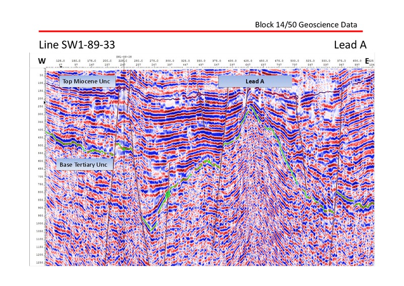
Block 14/50 Geoscience Data Line SW18933 Lead A W E Top Miocene Unc Lead A Base Tertiary Unc
BLOCK L14/50 Seismic Lead A Block 14/50 Geoscience Data North Phetchabun Basin Outline Lead A Scale = 10 Km
Block L14/50 Seismic Leads map Block 14/50 Geoscience Data North North Phetchabun Phetchabun Lead D Basin Basin Outline Outline Lead B Lead E Lead C Scale = 10 Km
Block 14/50 Geoscience Data Line SW18835 Lead B W E Lead B Top Miocene Unc. Base Tertiary Unc.
Block 14/50 Geoscience Data Line SW18831 Lead C W E Lead C Top Miocene Unc Base Tertiary Unc
Block 14/50 Geoscience Data Line SW18937 Lead D W E Lead D Top Miocene Unc Base Tertiary Unc
Block 14/50 Geoscience Data Line SW18933 Lead E W E Top Miocene Unc. Lead E Base Tertiary Unc.
Block 14/50 Geoscience Data 50km 2D Seismic Program
Block 14/50 Geoscience Data 2012 Seismic Program Results
Block 14/50 Geoscience Data Base Map
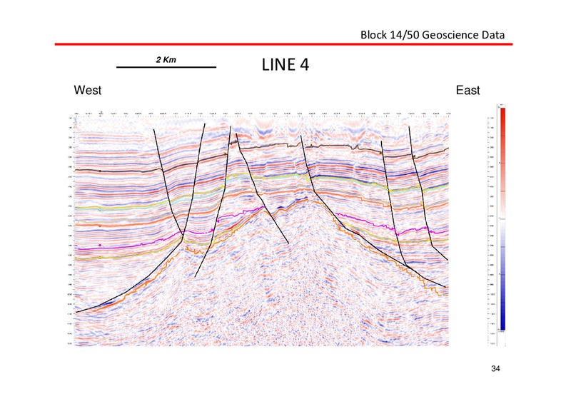
Block 14/50 Geoscience Data 2 Km LINE 4 West East 34
Block 14/50 Geoscience Data PreTertiary Time Structure Deepest
Block 14/50 Geoscience Data Mature Source Rock Areas Organic Rich Facies 1000 m depth
Block 14/50 Geoscience Data Lower Miocene Time Structure
Block 14/50 Geoscience Data MidMiocene Time Structure
Block 14/50 Geoscience Data Top Miocene Time Structure Shallowest
Block 14/50 Geoscience Data Locations A & B Relative to Base Tertiary Unconformity
Block 14/50 Geoscience Data Locations A & B Relative to MidMiocene (Green Horizon)
Block 14/50 Geoscience Data Locations A & B Relative to Lower Miocene (Pink Horizon)
2012 Line 4 Block 14/50 Geoscience Data LOCATION A Amplitude plot depicting bright spots terminating against the fault W E
2012 Line 4 Block 14/50 Geoscience Data LOCATION A Bright spot terminations against the fault, considered Direct Hydrocarbon Indicators (DHI) W E
2012 Line 4 Block 14/50 Geoscience Data LOCATION A Conventional Display W E
2012 Line 4 Block 14/50 Geoscience Data LOCATION A Conventional Display (Zoom) W E
Block 14/50 Geoscience Data Locations A MidMiocene (Green Horizon)
2012 Line 1 Block 14/50 Geoscience Data LOCATION B Conventional Display showing Horst W E
2012 Lines 1 & 6 Block 14/50 Geoscience Data LOCATION B Fence Display, Line 1 W/E and Line 6 S/N W E S N
2012 Lines 1 & 6 Block 14/50 Geoscience Data LOCATION B Amplitude Display Lines 1 & 6 Fence W E S N
Block 14/50 Geoscience Data Location A MidMiocene Time Structure
Block 14/50 Geoscience Data Location A Bottom Hole Location
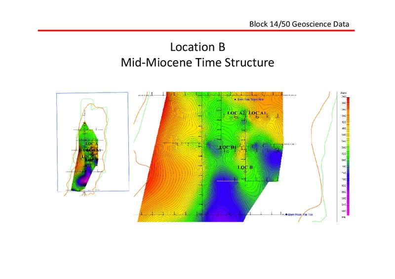
Block 14/50 Geoscience Data Location B MidMiocene Time Structure
Block 14/50 Geoscience Data APPENDIX A 2012 Seismic Lines
Block 14/50 Geoscience Data 2 Km LINE 1 West East 55
Block 14/50 Geoscience Data 2 Km LINE 2 West East 56
Block 14/50 Geoscience Data 2 Km LINE 3 West East 57
Block 14/50 Geoscience Data 2 Km LINE 4 West East 58
Block 14/50 Geoscience Data 2 Km LINE 5 South North 59
Block 14/50 Geoscience Data 2 Km LINE 6 South North 60
 Loading...